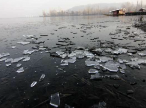
SRINAGAR: Srinagar recorded minus 3.7°C on Saturday, defying the recent trend of somewhat higher lowest temperatures in Kashmir, according to officials. Against normal weather patterns, Srinagar had a higher maximum temperature today than Jammu City. The day’s data highlights an unusual atmospheric situation in Kashmir despite extended dry weather conditions, with unexpected warmth in Srinagar. The MeT department has forecast light snowfall in isolated upper levels on January 25 and light rain and snowfall over sporadic locations in Jammu and Kashmir over the next two days. “Dry weather is likely to continue until January 24, with generally cloudy conditions on the evening of the 20th,” stated the meteorologist.Light snow is predicted for isolated upper elevations on January 25, and light rain and snow are predicted for scattered locations on January 26 and 27. “As per indications from different models, there is the possibility of light to moderate rain/snow at many places, and it is very likely from January 29-31,” said the official. Over the next three days, the MeT department also predicted a return of moderate to severe fog and a decrease in daytime temperatures over Jammu division. Officials from the Meteorological Department reported that while Srinagar registered an increase of 1.2°C from the previous night’s minus 4.9°C, the summer capital of Jammu and Kashmir was still 1.6°C below average for this time of year.The temperature at Qazigund was at least – 4.0°C, down from minus 5.0°C the night before, according to officials. This is 0.7°C below average for the gateway town of Kashmir. Compared to the previous night’s low of minus 6.3°C, Pahalgam in Anantnag reported a low of minus 5.5°C, which is 1.7°C above typical for the well-known south Kashmir resort. According to officials, Kokernag, in south Kashmir, saw a minimum temperature of – 2.0°C, which was higher than the previous night’s minus 1.4°C. The area’s average temperature was 1.9°C higher. The minimum temperature in the north Kashmiri district of Kupwara fell to minus 4.7°C from minus 5.0°C the night before, signifying a 1.6°C below-normal temperature. In contrast to the previous night’s low of minus 3.6°C, the ski resort of Gulmarg in north Kashmir reported a low of minus 4.6°C, with a temperature 3.1°C above average. The J&K winter capital of Jammu saw a lowest temperature of 5.9°C compared to 5.0°C the night before, which was 1.2°C below average, according to the meteorological service. The official reported a low of minus 1.4°C in Banihal, 1.9°C in Batote, and minus 0.4°C in Bhaderwah. We are currently experiencing “Chillai-Kalan” in the Kashmir valley, a hard 40-day winter season that ends on January 29.This does not, however, indicate the end of winter, since there is still a 20-day period known as “Chillai-Khurd” from January 30 to February 19 and a 10-day period known as “Chillai-Bachha” (baby cold) from February 20 to March 1. Against normal weather patterns, Srinagar had a higher maximum temperature today than Jammu City. Both people and meteorologists are interested in this peculiar weather phenomenon, wherein Srinagar records a greater maximum temperature than Jammu. Because of its position, Jammu usually has warmer winters than Srinagar, which has colder temperatures.

